viet nam
Earlier this year, I visited Vietnam. It was, for lots of reasons, an interesting trip to Asia.
 Photo by Jay Brown, Lijiang Studio
In many ways, Vietnam's physical landscape typifies the parts of the planet once known as the 'third world.' Like many developing nations in the midst of industrialization, it features the startling juxtaposition of intense poverty and concentrated wealth.
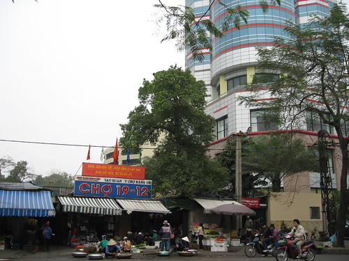 Located next to a modern office tower, the Cho 19-12 market sells some products not available in American stores.
At the same time, Vietnam's unique history and diverse cultural influences combine to make it a place unlike any other. The architecture of the nation reflects this singularity, and in the fabric of the built environment one can read the legacy of the various nations which have occupied it throughout its rich and varied history.
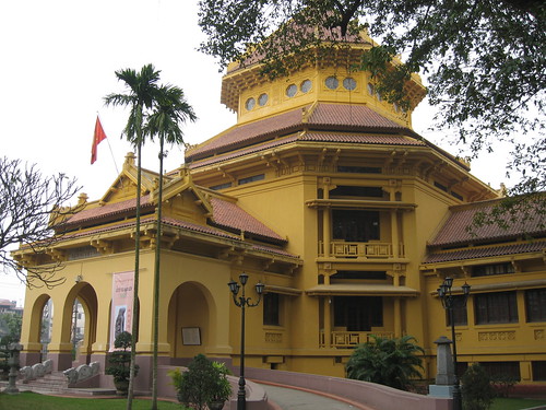 The Vietnamese History Museum, a French designer's interpretation of Chinese forms, epitomizes Hanoi's architecture.
In the United States, the name 'Vietnam' tends to conjure up the worst of the cold war. Especially in film, Vietnam is seen primarily as a battleground where the innocent youth of America were sent to kill the innocent youth of southeast Asia. That so many on both sides died for such unclear reasons only adds to the tragedy.
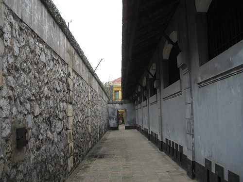 Hoa Lo prison (aka the Hanoi Hilton.) Built by the French for political prisoners and later adapted to hold US POWs. (Including John McCain.)
In Vietnam itself, a region which has dealt with invasions for millennia, the American war is but one facet of a long era of foreign occupation. Before the United States had a political interest in the area, both France and China made Vietnam a colonial battleground, and the mark of all three powers can be found in the physical character of the nation. (With a strong Soviet influence thrown in for good measure.)
A recent article in the New York Times documenting the impact of globalization on Vietnam made me recall my time in the country, and reinforced my belief that the Vietnamese are adept at not only surviving colonial occupation, but embracing the strengths of each occupying force and using them to their advantage.
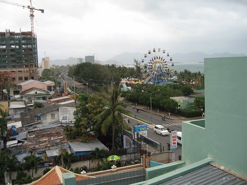 Nha Trang, burgeoning resort capital of Southern Vietnam. The far building under construction will be a Club Med.
One particularly interesting element of Vietnamese society is its street life. With pho (noodle) vendors on every corner and many wonderful public markets, there is much to celebrate. Still, it would be inaccurate to say that the streets were dominated by anything but the motorcycle.
In the two big cities I visited, Hanoi and Saigon (Ho Chi Minh City for my communist readers), motorcycle traffic exists at a density I would not have thought possible. Witnessing the apparent chaos at a busy intersection simultaneously reaffirmed and challenged my faith in the power of the invisible hand. I'm still not sure whether I think system 'works' or not.
I highly recommend visiting the Global South Mobility Library on YouTube. (via Bird to the North blog.)
Stop signs, traffic lights, and directional guides are rare, yet the motorcycle bound masses plow on. The phenomenon is especially interesting when considered in the context of new transportation planning theories advanced by David Engwich and Hans Monderman.
In his book Mental Speed Bumps, Engwich argues that by removing street signs, striping, and other delineations between automotive and pedestrian space, roads are actually made safer because drivers realize they are operating in places for people on foot. In practice, these theories have met with tremendous success in the Netherlands, where Dutch planner Hans Monderman has implemented them. (See Wired or the NY Times for a better explanation.)
Compare the video of Saigon to this footage from Groningen, Netherlands.
While I consider the work of Engwich and Monderman to be incredibly compelling and I think there is much to be learned from their ideas, it is critical to realize that their transportation plans are dependent upon the cultural norms of where they are applied.
Thus while it is the knee-jerk reaction of many New York planners to exclaim "'mental speed bumps' would never work in New York!", a more convincing argument, I think, is that they don't work in Vietnam.
I can watch these videos for hours, they're mesmerizing.
City plans of any sort, transportation or otherwise, must be based on a thorough understanding of the environment for which they are made. Engwich acknowledges this fact in Mental Speed Bumps. Wondering how the Dutch can share their public space so effectively, he points out the extent to the Dutch allow passersby to see into their living rooms from the sidewalk.
The Vietnamese, precisely because of their distinctive (and non-Dutch) culture, would probably have a different reaction to the removal of traffic organizing devices. This isn't to say that innovative transportation policies have no place in Vietnam -- it's just that those policies will need to be Vietnamese. (Interestingly, on my way to the airport in Hanoi, I did notice a BRT system.)
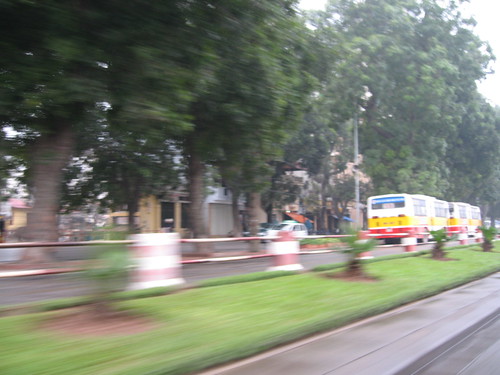 Toto, we're not in Rotterdam anymore.
Good planners anywhere, be it Vietnam, the Netherlands or the United States, must be intimately aware of the nuances and culture of the cities they work in. While very important lessons can be learned from studying the successes of city plans around the world, it is critical that those plans be harmonized with the place of their implementation. Vietnam, with its history of absorbing bits of Chinese, French, American and Soviet culture, provides a valuable lesson.
 Photo by Jay Brown, Lijiang Studio
In many ways, Vietnam's physical landscape typifies the parts of the planet once known as the 'third world.' Like many developing nations in the midst of industrialization, it features the startling juxtaposition of intense poverty and concentrated wealth.
 Located next to a modern office tower, the Cho 19-12 market sells some products not available in American stores.
At the same time, Vietnam's unique history and diverse cultural influences combine to make it a place unlike any other. The architecture of the nation reflects this singularity, and in the fabric of the built environment one can read the legacy of the various nations which have occupied it throughout its rich and varied history.
 The Vietnamese History Museum, a French designer's interpretation of Chinese forms, epitomizes Hanoi's architecture.
In the United States, the name 'Vietnam' tends to conjure up the worst of the cold war. Especially in film, Vietnam is seen primarily as a battleground where the innocent youth of America were sent to kill the innocent youth of southeast Asia. That so many on both sides died for such unclear reasons only adds to the tragedy.
 Hoa Lo prison (aka the Hanoi Hilton.) Built by the French for political prisoners and later adapted to hold US POWs. (Including John McCain.)
In Vietnam itself, a region which has dealt with invasions for millennia, the American war is but one facet of a long era of foreign occupation. Before the United States had a political interest in the area, both France and China made Vietnam a colonial battleground, and the mark of all three powers can be found in the physical character of the nation. (With a strong Soviet influence thrown in for good measure.)
A recent article in the New York Times documenting the impact of globalization on Vietnam made me recall my time in the country, and reinforced my belief that the Vietnamese are adept at not only surviving colonial occupation, but embracing the strengths of each occupying force and using them to their advantage.
 Nha Trang, burgeoning resort capital of Southern Vietnam. The far building under construction will be a Club Med.
One particularly interesting element of Vietnamese society is its street life. With pho (noodle) vendors on every corner and many wonderful public markets, there is much to celebrate. Still, it would be inaccurate to say that the streets were dominated by anything but the motorcycle.
In the two big cities I visited, Hanoi and Saigon (Ho Chi Minh City for my communist readers), motorcycle traffic exists at a density I would not have thought possible. Witnessing the apparent chaos at a busy intersection simultaneously reaffirmed and challenged my faith in the power of the invisible hand. I'm still not sure whether I think system 'works' or not.
I highly recommend visiting the Global South Mobility Library on YouTube. (via Bird to the North blog.)
Stop signs, traffic lights, and directional guides are rare, yet the motorcycle bound masses plow on. The phenomenon is especially interesting when considered in the context of new transportation planning theories advanced by David Engwich and Hans Monderman.
In his book Mental Speed Bumps, Engwich argues that by removing street signs, striping, and other delineations between automotive and pedestrian space, roads are actually made safer because drivers realize they are operating in places for people on foot. In practice, these theories have met with tremendous success in the Netherlands, where Dutch planner Hans Monderman has implemented them. (See Wired or the NY Times for a better explanation.)
Compare the video of Saigon to this footage from Groningen, Netherlands.
While I consider the work of Engwich and Monderman to be incredibly compelling and I think there is much to be learned from their ideas, it is critical to realize that their transportation plans are dependent upon the cultural norms of where they are applied.
Thus while it is the knee-jerk reaction of many New York planners to exclaim "'mental speed bumps' would never work in New York!", a more convincing argument, I think, is that they don't work in Vietnam.
I can watch these videos for hours, they're mesmerizing.
City plans of any sort, transportation or otherwise, must be based on a thorough understanding of the environment for which they are made. Engwich acknowledges this fact in Mental Speed Bumps. Wondering how the Dutch can share their public space so effectively, he points out the extent to the Dutch allow passersby to see into their living rooms from the sidewalk.
The Vietnamese, precisely because of their distinctive (and non-Dutch) culture, would probably have a different reaction to the removal of traffic organizing devices. This isn't to say that innovative transportation policies have no place in Vietnam -- it's just that those policies will need to be Vietnamese. (Interestingly, on my way to the airport in Hanoi, I did notice a BRT system.)
 Toto, we're not in Rotterdam anymore.
Good planners anywhere, be it Vietnam, the Netherlands or the United States, must be intimately aware of the nuances and culture of the cities they work in. While very important lessons can be learned from studying the successes of city plans around the world, it is critical that those plans be harmonized with the place of their implementation. Vietnam, with its history of absorbing bits of Chinese, French, American and Soviet culture, provides a valuable lesson.
