Saturday, November 13

2010 election cartograms

Also, election cartograms are fascinating.

This electoral cartogram was made by Michael Gastner. Here's my labeled version of the 2008 election cartogram made by Mark Newman.

not a chicago tatoo

chicagoskyline

Just came across a mock-up of a design for a Chicago tatoo that a friend requested a few years ago. He didn't end up getting the tatoo, but I still like the sketch.

Thursday, October 28

link it up

I've finally got around to updating the other webpages I link to on the Built Environment Blog and I thought I'd highlight a few of the new additions.

Docks
Guano Loading Infrastructure, Peru. From Oliver Whiteside via F.A.D.


One of my very favorite reads these days is Free Association Design, a tangent-rich blog based in Portland. I can't remember how I came across F.A.D. at first, but I became a regular reader after reading a post on Reclaiming the Florida Everglades. I was impressed by its surefooted explanations of the complex biological, economic and political forces at work in that unique environment. (I like the posts on goats and bird poop, too.)

Although I've seriously reduced the number of NYC and Brooklyn blogs I read, I've added Urban Omnibus to the list of Empire State blogs I follow. This week I'm particularly delighted to link to them as they feature Underline, a project by a good friend and UC Berkeley classmate. While Underline is a site-specific intervention suspended in the negative space between the Culver Viaduct and the Gowanus Canal in Brooklyn, the project makes an important point about how we think about leveraging the structures we already have in cities -- an oft overlooked element of sustainable urban design.

Underline Section. By John McGill, via Urban Omnibus

I would be very impressed if any of my readers noticed that the link to the defunct Polis blog, once written by Slackonomics author and Forum for Urban Design executive director Lisa Chamberlain, was replaced with the Polis blog, an international group blog distantly related to the now defunct Where blog, where I was briefly a contributor a couple years ago.

Moving to San Francisco has brought other new awesome stuff to my attention. Ever since they gave me a free membership after I caught them poaching one of my flickr photos without credit for their magazine Urbanist, I've been a huge fan of SPUR. Besides fighting the good fight for San Francisco, the events they put on at their downtown headquarters are lots of fun. (If you haven't seen it yet, you've got two more days to see the DIY Urbanism exhibition.)

Southern Pacific Diesel Shop
Southern Pacific Diesel Shop. Demolished October 2010. Photo by Todd Lappin.

I also have two new favorite San Francisco blogs. I've already posted to a map from Burrito Justice, so it's only fair to link to Telstar Logistics now. (Burrito Justice's "Know Your Trees" post is my go-to guide for San Francisco tree identification.) I must admit I'm totally incapable of categorizing Telstar Logistics into any specific kind of blog -- but it's great. Sadly, sometimes I learn about things from Telstar only when it's too late -- despite driving past it dozens of times, I never noticed the Southern Pacific Diesel Shop. (Another great San Francisco discovery has been the Flickr photostream of Eric Ficsher. His series of US city race and ethnicity maps are powerful.)


I've decided to keep up some of the other links I had on the old blog even though I haven't done the best job keeping up with them. In the process of pruning down the list, for example, I came back across Fogonazos, a Spanish blog I was never really able to fully read due to my mediocre language skills. Fortunately, videos of houses getting blown over in enormous wind tunnels are awesome in any language.

Wednesday, October 6

hardly strictly diy wayfinding

Another foggy weekend, another great festival in the bay. This past weekend I went to my third Hardly Strictly Bluegrass, a remarkable free annual music festival in Golden Gate Park. Investment banker and banjoist Warren Hellman foots the bill every year, calling the event "The closest I'll ever get to heaven."

Hardly Strictly Bluegrass 2010 2010-10-0132
Banjo Stage. Photo from Steve Rhodes


Besides the consistently outstanding acts and the generally groovy vibe, Hardly Strictly Bluegrass offers a great opportunity to observe how large groups of people can organize themselves in interesting ways. In past years, for example, I've marveled at how people use flags, balloons, and other props to make landmarks within the crowd. It's sort of a do-it-yourself wayfinding exercise pursued without official instructions or sanction.

IMG_7759.JPG
At 2009's HSB, I was only able to find my friends by virtue of their proximity to an osprey kite.


This year, planning ahead, I brought several lengths of dowels, a roll of duct tape, and a blue handkerchief to Rooster stage, where Sharon Jones and the Dap-Kings were due to play at the end of the day. Fashioning a crude flag pole from the dowels and duct-taping it to a steel barricade, I raised my beacon to the crowd and text messaged my friends. By the time Sharon was shimmying across the stage, there were dozens of us dancing under the blue bandana. (Which my phone's auto-spell misleadingly corrected to "blue banana.")

IMG_2819.JPG
Phone calls were impossible due to the noise and dropped calls, despite cell providers' extra coverage.

While cell phone users now have the ability to georeference themselves and send the location to their friends via FourSquare, Twitter, or Facebook Places, the combination of a relatively old digital technology, text messaging, and an even old communication method, flags, proved to be a remarkably effective means of marking a specific place among an otherwise anonymous crowd.

Lonely Flag Marker
Photo from James Mourgos

Reflecting on the flag-text combination, I realized that the effectiveness of the endeavor came from the coordination of a physical action in the landscape with a message sent on social media. It was a tiny example "emergent urbanism," a term I have adopted loosely from Dan Hill to describe coordinated action in cities coordinated through digital networks. Regardless of what sort of urbanism may or may not have emerged at Hardly Strictly Bluegrass, it was a fabulous show enhanced by great company. I can promise I'll be back next year to continue my research.

Thursday, September 23

Doppelstock-Containertragwagen

It's been a very Teutonic week for me. It all started when I received a copy of the August issue of Garten+Landschaft, a German landscape architecture journal. Usually I prefer to read about the newest developments in landscape in a language I can understand, but this was different: my Berkeley Master's thesis, Network-Landscape: The Internet and the Urban Site, was featured in the "Campus" section.

Garten+Landschaft_NetworkLandscape
The August Issue also features what I can only imagine is a wonderful piece by one of my 
thesis advisers, Professor Judith Stilgenbauer.


Network-Landscape describes a framework for understanding the relationship between physical places and flows of information over digital networks. In the thesis I describe a typological framework of Network-Landscape interactions that describe how online content can be projected into space or environmental conditions can be sampled and uploaded to the Internet. The graphic featured in Garten+Landschaft illustrates the concept of augmented reality, which is one way that media about a specific place can be projected into mobile network infrastructure. I'm hoping to delve a little more deeply into Network-Landscape in coming posts -- stayed tuned for information about crowdsourcing spatial data, commons-based peer-production, and emergent urbanism.

The arrival of Oktoberfest also delivered another German flavor to my week: beer. I was fortunate to be a last minute invitee to the Tourist Club in Marin, a cabin and beer garden tucked into the hills near Muir Woods.

IMG_2567.JPG
The Tourist Club

An intense fog that was initially a bummer ended up being one of the best things about the day. Nearly thick enough to swim through, the mist lent the afternoon a supernatural air -- it seemed that we had found a beer garden in the clouds.

IMG_2697.JPG
To get to the German beer garden, we had to hike through a forest of Australian eucalyptus.

The final German element of my week was a discovery I made as I was checking the traffic on my flickr photostream. I was getting hits from German Wikipedia -- something I had never noticed before. Upon further investigation, I learned that a photo of a freight train I took in Berkeley several years ago had been uploaded.

IMG_2545.JPG
A double-stack container-train. Or, as they say in Germany, a Doppelstock-Containertragwagen.


While certainly not my most prominent image on Wikipedia, (someone put my photo of the Flatiron's interior on the building's page,) I was delighted to find it. What a fitting wrap up to my German week! Prost!

Saturday, September 11

Re-start

Heading to Dolores park last week, I noticed parallel marks in the pavement that seemed to be the shadows of an old railroad. As a relatively new resident in the Mission, I commented to my new roommate: "There must have been a streetcar line here."

IMG_2457.JPG
Dolores Street between 17th and 18th

"No way." My roommate responded. I pondered San Francisco's urban development, the transformation of the city with the arrival of the automobile, and the history buried under the pavement. I bet her a six-pack there used to be a streetcar on Dolores Street and decided to restart the Built Environment Blog.

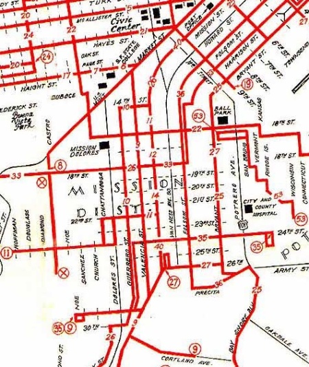
This map shows that there was a streetcar on Dolores in 1943 -- but not between 17th and 18th.
Map from Central Pacific RR Museum via Burrito Justice, one of my favorite San Francisco blogs. 
Bet undecided.

Some things will be the same in this newest phase of the Built Environment Blog. I've still got my independent perspective, and I still take tons of pictures. But after three years of landscape architecture school I'm more into soil and plants than I used to be. I've also gotten to know some fascinating designers and planners, and I've moved to the Mission in San Francisco. I'm still way into old buildings and urban puzzles, though, don't worry.


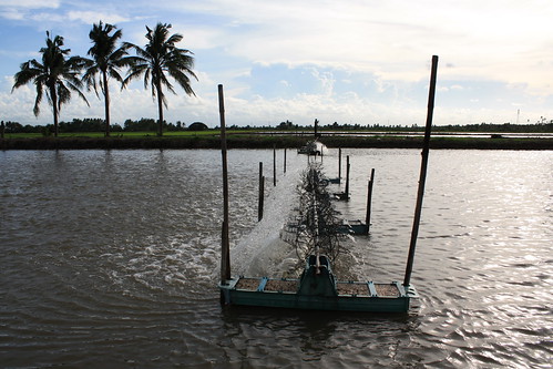
There may be a post about shrimp farming, at some point.
You can view most photos full-size on my flickr just by clicking them.

I still save an eclectic set of bookmarks at my del.icio.us page and I've also joined Twitter. I tend to retweet more than I post original content, but I find the whole twitter phenomenon fascinating.

Please feel free to post critiques and questions in the comments, or e-mail me through the link at the top right of the sidebar. This should be fun!

Sunday, November 2

where am I


After a roughly year-long break, I've decided to start blogging again. Instead of keeping things going full time here at the Built Environment Blog, though, I'll be contributing several posts a month to Where, which has evolved into an interdisciplinary forum on urbanism with 11 international writers. Needless to say, I'm thrilled to be involved -- it promises to be an interesting endeavor. (I also got to design the banner!)

Friday, October 19

not so superblock

In an interview with the New York Observer several months ago, the Atlantic Yards' landscape architect Laurie Olin dismisses the common stigma against superblocks as clichéd "1960s language." His own arguments for them, however, echo the naïve idealism of planners from that very era. "If I put a street through here," he states, "[then] I have less space for people and I have more cars… When people say 'superblock'— what's wrong with what this is? Because I don't see how adding one car in here is going to make it a better space. I think space on streets is actually useless space."
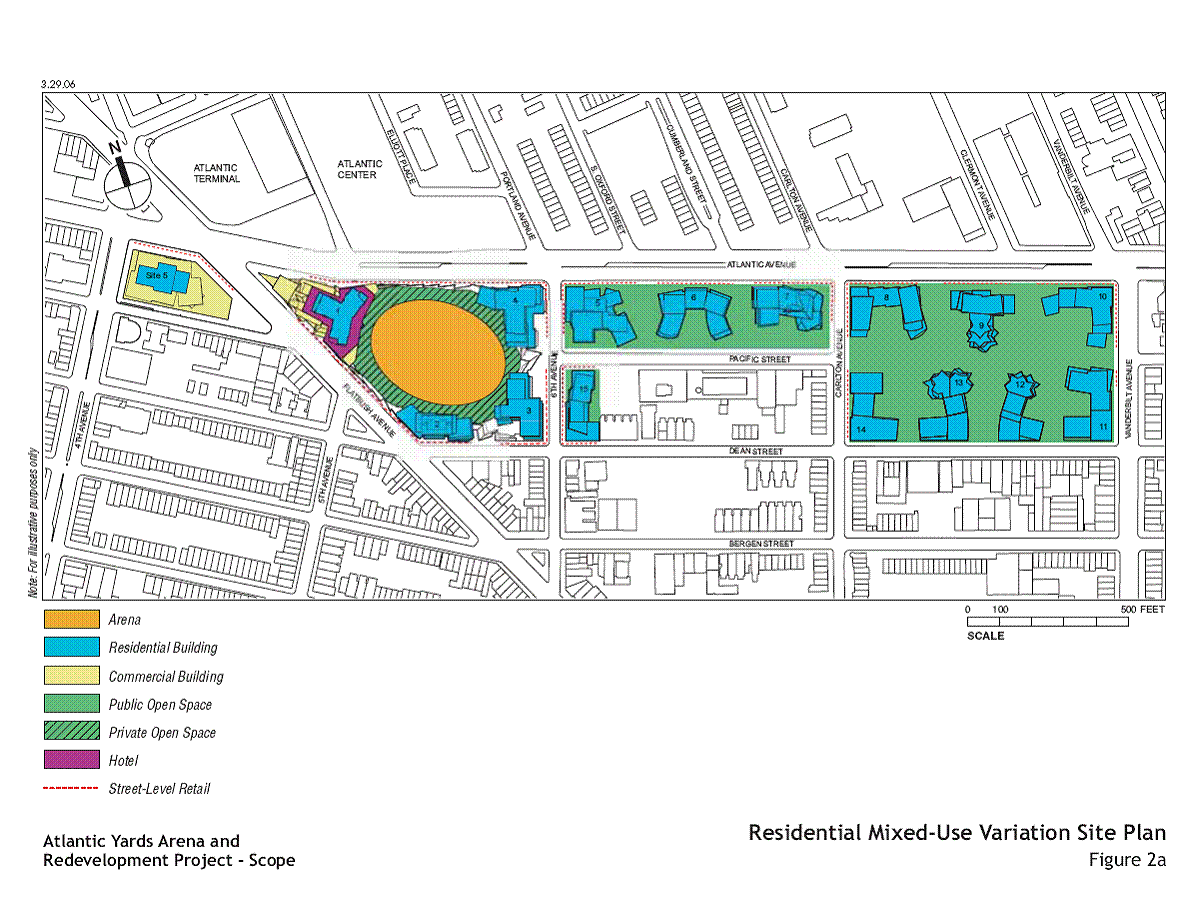
The current plan for Atlantic Yards involves the demapping of several streets and the creation of a residential superblock. Site Plan via Atlantic Yards Report.

The superblock, put very simply, is a development form larger than a traditional city block. According to civic-minded urban theorists in the mid-20th century, residents of superblocks would be liberated from cars in their everyday life, living freely as denizens of self-sufficient pedestrian communities. The scale of these superblocks, wrote Bauhaus urban planner Ludwig Hilberseimer, would allow them to "preserve an organic community life" in the face of automobile-based cities of the future. (The Nature of Cities, 1955.)

hilberseimersuperblock_a.jpgConcept for Heerstrasse and University of Berlin, 1937. Ludwig Hilberseimer. Scanned from The American City: What Works, What Doesn't by Alexander Garvin. Hilberseimer worked with Mies van der Rohe on the United States' most successful superblock project: Lafayette Park in Detroit.

In practice, completed superblock projects rarely approach Hilberseimer's utopian vision: for the most part, superblock projects are boring and institutional. At worst, the designs encourage crime and neglect.

The NYU Silver Towers project north of Houston between Mercer and LaGuardia demonstrates the detrimental effect that the demapping of streets to create superblocks can have on the public realm. Despite an elegant design by I.M. Pei and a plaza with public art by Picasso, the modest superblock is a dead zone in the Village's otherwise vibrant public realm. Compared to neighboring SoHo – which has streets filled with a jumble of people and uses – the Silver Towers are a public realm failure.

NYU’s Silver Towers, a superblock created by the demapping of Wooster and Greene Streets, lacks the vitality of the smaller blocks that surround it. Photo by Hubert Steed.

With the rise of New Urbanism and the canonization of Jane Jacobs, superblocks became a sort of urban design taboo – the quintessential example of high-minded architectural theory failing in real world application. Thus of the myriad flaws in the plan for Ratner's Atlantic Yards development in Brooklyn, perhaps the most surprising, from a design perspective, is its return to the superblock form. In the words of the Manhattan Institute's Julia Vitullo-Martin, "Do we not all agree with Jane Jacobs that the urbane mixtures of buildings of varying age, condition—inevitably swept away by the superblock—are a necessary condition of thriving urban life?"

Apparently not.

One dissenter, it seems, is Olin. In the past, Olin has demonstrated an incredible ability to create beautiful public space enclaves in crowded urban environments. At the Getty Center in L.A., he worked with Richard Meier to create a hilltop oasis for art; at Bryant Park, he collaborated with William Whyte to carve a cozy community park from the mind-boggling intensity of Midtown Manhattan.

Bryant Park. Photo from Forgotten NY.

Unfortunately, Olin's talents do not always translate well into projects meant to integrate into the fabric of the city, rather than stand out from it. At Canary Wharf in London – like Atlantic Yards, a mixed-use high-rise development on a post-industrial site – the public spaces planned by Olin are impersonal and lack activity. Despite crowds of people working in the area, the wharf's public spaces are often nearly deserted. (It's said that the Radiohead's Fake Plastic Trees is about Canary Wharf, even though the trees are real. For more criticism, see the Project for Public Space’s Hall of Shame.)


Canary Wharf Tube Station, London, U.K. Image from yuki*.

In the chapter of The Death and Life of Great American Cities entitled "The Need for Small Blocks," Jacobs bemoans the "myth that plentiful streets are 'wasteful.'" She argues that it is, in fact, large blocks that lead to wasted space by constricting "economic use [to] only where [people's] long, separated paths meet and come together in one stream." The consolidation of economic activity to confined geographic areas leads to a "depressing predominance of commercial standardization... [and] the Great Blight of Dullness." Ultimately, it is the presence of streets where things can "start up and grow" that lead to economic vitality and vibrant public space.

needforsmallblocks_2Potential pedestrian paths on large blocks (left) vs. potential pedestrian paths on short blocks (right.) From The Death and Life of Great American Cities, by Jane Jacobs.

In his defense of the Atlantic Yards superblock, Olin ignores the lessons of Jacobs while also revealing a fundamental misunderstanding of Brooklyn's streets. In vibrant neighborhoods like those surrounding Atlantic Yards, streets are more than a means of reaching a destination: they are the destinations themselves. Besides providing a place for cars to drive, Brooklyn's streets host a diversity of restaurants, stores, and cultural institutions – all of which serve customers arriving via public transportation or on foot. Moreover, the borough often closes its avenues completely to traffic to host festivals and fairs, events that have helped to give Brooklyn the value that Ratner, the Atlantic Yards' developer, is so eager to capitalize on. By asserting that "space on streets is actually useless space," Olin demonstrates a profound ignorance regarding Brooklyn's urban form.

The Atlantic Antic, Brooklyn, NY. (This festival takes place on Atlantic Avenue -- the northern limit of the of the Atlantic Yards development.) Photo from Apollonia666.

Perhaps what is most surprising about the Atlantic Yards' superblock plans isn't the designers' defense of the concept, but the support it has from its developer. Small blocks, Jacobs makes it clear, are better for business. If he knew better, Ratner would be pushing for more streets – not fewer. Indeed, the superblock is neither a pedestrian-friendly design statement nor a wise investment – it's just a mistake.

Monday, October 8

prison payola

The Next American City just released an issue focusing on crime for which I wrote an article on prison privatization. It was a fascinating topic to research, but also incredibly frustrating: there are lots of examples of what doesn't work well and very few of what does.

Photo from NY Times

If you haven't seen The Next American City, check it out -- it's an interesting organization and the magazine has a thoughtful, interdisciplinary approach to urbanism.

If you're interested learning more about prison privatization, there's lots out there. Crime Pays is an award-winning radio documentary about private prisons. The New York Times featured a great article on the topic earlier this year. Finally, for a rigorous analysis of the ethics of private prisons, see State Punishment and Private Prisons, a piece that appeared in the Duke Law Journal in 2005.

Wednesday, August 29

hiatus

I had been wondering if grad school would leave me enough time to keep writing the Built Environment Blog, and after one day in the studio I have my answer: no.

Also, an earthquake hit yesterday -- my first! It was apparently a 3.0, but I didn't really feel it, I just heard a big rumble.

Even though I won't be writing long posts like fireproof or Grand Army Plaza, Built Environment Blog won't be totally static. The links from del.icio.us and photos from flickr will keep updating, and I'll try to share interesting discoveries about the Bay Area as I make them.

IMG_5129.JPGBerkeley Rose Garden

If you're looking for something interesting to read online, there's still no better place than BldgBlog. Things Magazine is another source for awesome stuff, and Where keeps getting better.

Monday, August 13

cross country

I recently completed a two-month trip across the country. There were two legs of the journey and I took lots of photos on both of them. The first part, from Brooklyn to Chicago by car, took place at the start of the summer. The second part, from Chicago to the Bay Area by plane, took place at the end. Each leg provided a distinct perspective on the American landscape and I had a window seat for both.

IMG_0659aFreight train, Ohio.

From the car, I saw a thin slice of the country, but from quite close. In addition to hearing the horns of freight trains, I could also smell the chicken coops. (It makes you wonder what they do in there...)

From the airplane, I saw a broad swath of the country from a great distance. On the one hand, I could really appreciate the geography of the American West. (I was particularly drawn to its dams and reservoirs.) On the other hand, I didn't get to go to any of the places I saw.

IMG_3925_b_b.jpgFarmland, California.

On both segments of the trip I saw farms. There are, I learned, lots of different kinds of farms.

IMG_0246.JPGFarmland, Pennsylvania.

Some farms are center pivot irrigated -- watered by sprinklers that rotate around a central point. From the ground, these sprinklers look a bit a like a suspension bridge, fork-lift, and garden hose all rolled into one device.

IMG_0683.JPGCenter pivot irrigation sprinkler, Ohio.

The true beauty of center pivot irrigation, however, is only visible from above. By virtue of their radial design, farms using the system have crops arrayed into circles. Sometimes the countryside looks like it's covered in pie-charts.

IMG_3894_b_b.jpgCenter pivot irrigated farms, Southwestern US. (Central pivot irrigation has been used to grow crops in the Sahara!)

Another kind of 'farm' I saw didn't grow anything at all: it produced power.

IMG_0270.JPGWind farm, Pennsylvania.

The first wind farm I saw was in western Pennsylvania. The towering three-bladed turbines were a striking juxtaposition to the traditional dairy farms on the ground. Nonetheless, windmills seemed like a good fit in Amish Country.

On the approach to Oakland Airport, I got another look at a wind farm when my plane flew over Altamont Pass. Constructed in response to the 1970s energy crisis, the Altamont Pass Wind Farm was once the largest in the world. From above, it's almost impossible to see the propeller blades move; instead of looking like power plants, the turbine arrays look like battalions of toy soldiers. (Fighting for the environment, of course.)

IMG_3929_b_b.jpgAltamont Pass Wind Farm, California.

Despite enjoying the journey west -- as well as the two month layover in Chicago -- I'm glad it's over. It's nice to be finally be here in California.

Saturday, July 7

sail to the crib

Last Monday, I decided to have my class sail out to the the Wilson Avenue crib. Sailing to the crib is good practice navigating in large waves -- it also makes the kids more independent and gets them comfortable being further from shore. Getting somewhere on a sailboat is fun, too, instead of just going around buoys.

IMG_2594.JPGA boat practicing trapezing on the way to the crib.

Accompanying my sailors in a safety boat, the trip also afforded me a close look at a work of historic engineering. Built in early 1900s, the Wilson Avenue crib is part of the massive hydrological infrastructure that gives Chicago its drinking water. (The most famous part of the system is the Sanitary and Shipping Canal, which reversed the flow of the Chicago River in 1900.)

Chicago Sanitation DistrictThe Chicago Sanitation District, 1925. (Now known as the Metropolitan Water Reclamation District of Greater Chicago.)

When operation began in 1866, the first crib pulled clean water through pipes from two miles offshore to a water tower at the corner of Michigan and Chicago Avenues. Meant to equalize water pressure, the water tower gained great fame as one of the few structures to survive the Great Chicago Fire in 1871.

IMG_1961.JPGTo this day, the land between the water tower (above) and the two-mile crib (which no longer exists) is conspicuously unbuilt -- only the Museum of the Contemporary Art has been built above the old pipes' path.

Though the original crib is long gone, others, like the Wilson Avenue crib, remain in operation today. These cribs collect lake water and send it ashore to be purified. One of Chicago's chemical purification plants, the Jardine Water Purification Plant, is the largest in the world.

IMG_2760.JPGThe Wilson Avenue crib, from just beyond the restricted area created after 9/11.

As a place, the crib feels very surreal. In some ways, it's familiar: I see the crib almost every day. At the same time, though, viewing it from the far side -- and from so close -- make being there totally foreign.

Seeing Chicago's skyline from the crib always makes me feel a bit like an astronaut seeing earth from the moon.

Some of my students call the crib "Azkaban," the wizards' prison from Harry Potter. Although the residents weren't prisoners, the cribs were once inhabited by tenders. Today, however, the systems are automated: no one has lived on the structures for decades.

IMG_2677.JPG
Chicago from the Wilson Avenue crib.

As a waypoint, a historic building, and a place, the crib is fascinating. I always love to sail to the crib.

(Full photoset of the trip here.)

Sunday, June 17

got the t-shirt

Before starting landscape architecture school in the fall, I thought it would be a nice change of pace to coach sailing in Chicago this summer.

IMG_0960.JPGBelmont Harbor.

Even though the whole plan was to avoid design work for a few months, I couldn't help but get excited when my boss offered $100 to the instructor that designed the best sailing school t-shirt.

Living in Chicago for the first time in 7 years, I've found that the Hancock Center has supplanted the Sears Tower as the city's favorite skyscraper. I decided to incorporate the tapered tower into my t-shirt design.

IMG_1288.JPGThe Hancock Tower.

Pondering the iconic building's distinctive cross-bracing, I couldn't help but think of one of my favorite sights in sailing: two boats crossing tacks upwind. After some online searching, I was able to find a great piece of graphic design from the 1987 America's Cup.

Duel, by Keith Reynolds. (From AllPosters)

Initially, I thought that the graphic would be a bit sparse with only one tower, so I decided to incorporate two other iconic Chicago buildings.

The Sears Tower. (From LensImpressions)

The Smurfit-Stone Building. (From ChicagoSage)

When I finished the design, however, I thought it was a bit busy.

cyc shirt_7d.jpg

I took out the Sears Tower and the Smurfit-Stone, but I'm not sure it's better. Which one do you like?

cyc shirt_7c.jpg

We'll see what the other instructors come up with...

Wednesday, June 6

under construction

Last year I moved into a new apartment in Prospect Heights, Brooklyn. I loved the place, but there was one problem: a new building was under construction next door. When I complained about the noise, however, my dad made a good point: 'At least you can learn how they build apartment buildings.'

IMG_1926.JPGJune 1, 2006.

When I visited the apartment for the first time, contractors were clearing the remains of old garages that had been demolished on the site.

IMG_2168.JPGAugust 15, 2006.

Within a few weeks, the builders were digging foundations for the new building.

IMG_3690.JPGSeptember 13, 2006.

For about a month, a pumping truck poured concrete into wooden frames to build the foundation.

IMG_4732.JPGOctober 14, 2006.

Once the foundation was finished, prefabricated concrete floor plates were lifted on top. When the floor plates were anchored into place, workers built cinder block walls to support the next level.

IMG_4812.JPGOctober 26, 2006.

As each set of walls were completed, a new set of floor plates were lifted by a crane into place.

IMG_5549.JPGNovember 18, 2006.

And then another level of cinder block walls was added...

IMG_5851.JPGDecember 6, 2006.

The large crane that lifted the floor plates into place is visible in this photo. On days like this when the floors were being installed, the street was filled with 18-wheelers carrying prefabricated concrete plates.

IMG_6612February 10, 2007.

During a powerful windstorm in February, several strips of plastic blew off the roof and over the side of the building. They made a loud whipping sound that kept me up at night -- it was quite annoying. It was the only time that it seemed like anything went awry in the process, though. Overall, I was very impressed with the efficiency of the construction.

IMG_6810.JPGFebruary 26, 2007.

By the time winter started flexing its muscle, most of the structural elements were finished. As snow fell on the site, the construction workers were installing elements of the building's interior.

IMG_6868.JPGMarch 3, 2007.

On the night of March 3rd, the construction site was lit by a partial lunar eclipse. It was a surreal sight.

IMG_7721.JPGApril 10, 2007.

IMG_8051.JPGApril 19, 2007.

By mid-April, work had begun on the cosmetic elements of the building's exterior. Exposed cinder block walls were covered in brick and the window panes were put in place.

IMG_0437.JPGMay 21, 2007.

IMG_0164.JPGMay 31, 2007.

365 days after I first photographed the construction site, the lease on my apartment expired. After I finished moving out, I made sure to return one last time to take a final picture. Soon the building will be finished, but I won't get to see it. Nonetheless, my dad was right: now I know how they build apartment buildings.

Full construction photoset here.